 Note: the Richter was subsequently upgraded to 9.0, then to 9.2.
 Note: the Richter was subsequently upgraded to 9.0, then to 9.2.
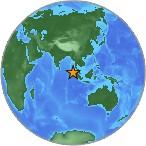
A great earthquake occurred at 00:58:50 (UTC) on Sunday, December 26, 2004. The magnitude 8.9 event has been located off West Coast of Northern Sumatra. (This event has been reviewed by a seismologist.)
Magnitude 8.9
Date-Time Sunday, December 26, 2004 at 00:58:50 (UTC)
= Coordinated Universal Time
Sunday, December 26, 2004 at 6:58:50 AM
= local time at epicenter
Time of Earthquake in other Time Zones
Location 3.298°N, 95.779°E
Depth 10 km (6.2 miles) set by location program
Region OFF THE WEST COAST OF NORTHERN SUMATRA
Distances
250 km (155 miles) SSE of Banda Aceh, Sumatra, Indonesia
320 km (200 miles) W of Medan, Sumatra, Indonesia
1260 km (780 miles) SSW of BANGKOK, Thailand
1605 km (1000 miles) NW of JAKARTA, Java, Indonesia

Location Uncertainty horizontal +/- 9.2 km (5.7 miles); depth fixed by location program
Parameters Nst=157, Nph=157, Dmin=>999 km, Rmss=1.35 sec, Gp= 29°,
M-type=moment magnitude (Mw), Version=9
Source USGS NEIC (WDCS-D)
Event ID usslav
Felt Reports At least 2,200 people killed in Sri Lanka, 1,600 in India, 700 in Indonesia, 220 in Thailand, 29 in Malaysia and 2 in Bangladesh by tsunamis. Tsunamis also occurred on the coasts of Maldives and Cocos Island. At least 200 people killed, buildings destroyed or damaged in the Banda Aceh area, Sumatra. Felt widely in Sumatra. Also felt in Bangladesh, India, Malaysia, Myanmar, Singapore and Thailand. This is the fifth largest earthquake in the world since 1900 and is the largest since the 1964 Prince William Sound, Alaska earthquake.